
01843 585310
info@kentandessex-ifca.gov.uk
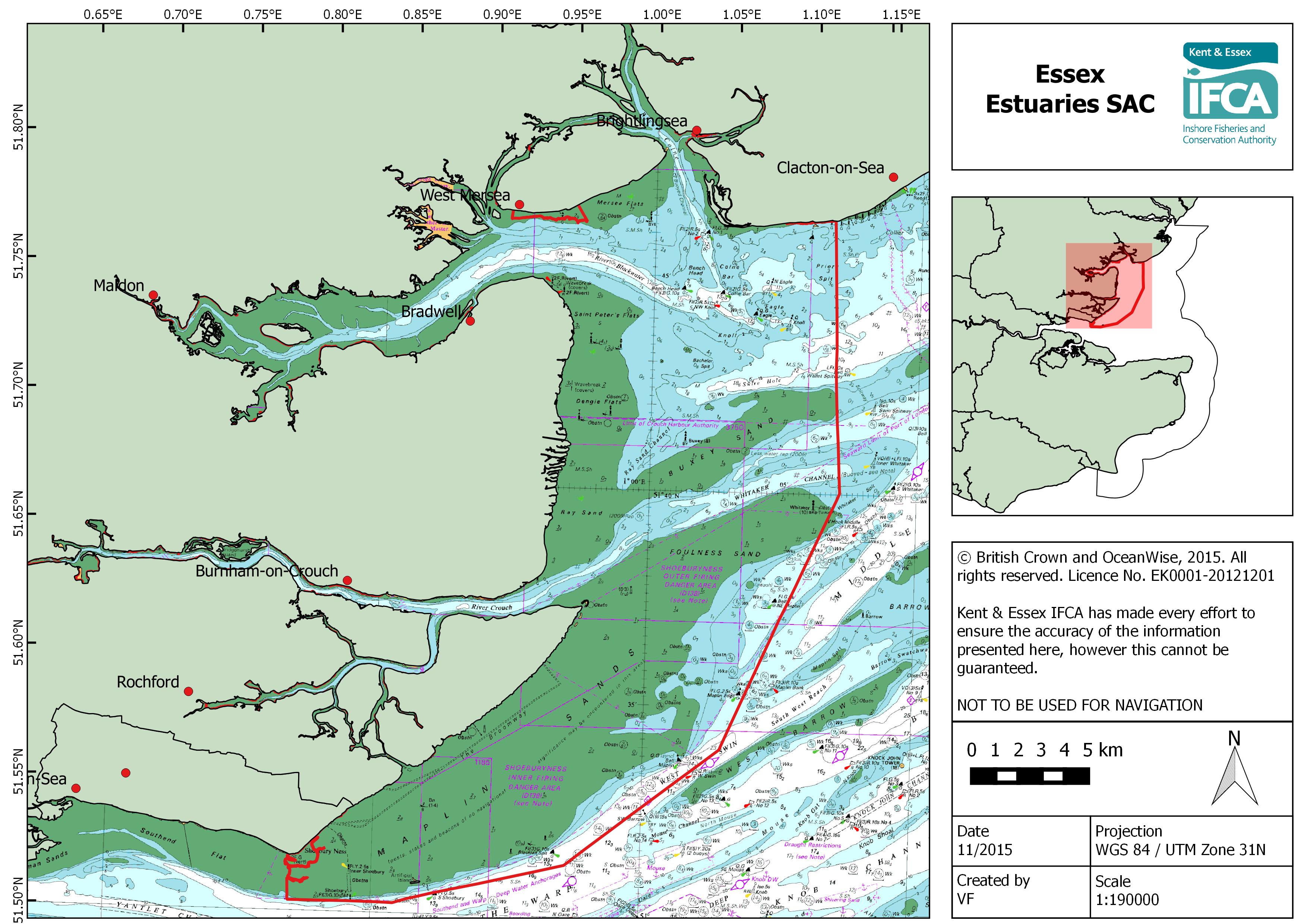
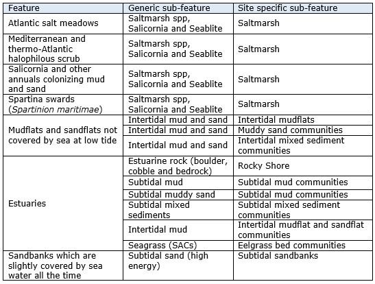
Table 1. Qualifying features and sub-features of Essex Estuaries SAC
Site overview
Essex Estuaries SAC is a 472 km2 site which was initially designated for six Annex I habitat features under the EU habitats directive. The seventh feature, subtidal sandbanks, is present as a qualifying feature but not a primary reason for selection of this site. Thirty percent of the SAC is comprised of marine areas and sea inlets, 56.5% is tidal rivers, estuaries, mud flats, sand flats, and lagoons (including saltwork basins), 11% is saltmarshes, salt pastures and salt steppes, 2% is improved grassland and the remaining 0.5% is composed of shingle, sea cliffs and islets (JNCC, 2015).
Saltmarshes
Saltmarshes nationally are under pressure from ‘coastal squeeze’, with coastal developments and flood defences constraining the ability of saltmarsh habitats to naturally move landward in response to sea-level rises (Natural England, 2006). Approximately 3,500 hectares, or 8%, of the UKs saltmarsh resource lies within the SAC boundaries (Natural England, 2000). Saltmarshes in Essex Estuaries contain nationally scarce species including small cordgrass (Spartina maritima) and smooth cordgrass (S. alterniflora).
Mudflats and sandflats not covered by sea at low tide
This site encompasses the extensive intertidal flats of the Colne, Blackwater, Roach and Crouch, as well as the tidal flats at Foulness, Maplin and Dengie. The flat communities within this site cover a wide range of sediments, including mud, muddy sand and clean sand (Natural England, 2000). Mud communities are found in the upper reaches of the river, where variable salinity leads to impoverished communities (Natural England, 2000). Further down river, communities in sandy mud are more diverse, including marine bristle worms, Baltic tellins, cockles and mud snails. Muddy sand communities occur towards the mouth of the estuaries support a 58 hectare nationally-important bed of dwarf eelgrass (Zostera marina) on Maplin sands, as well as a nationally important cockle fishery (Natural England, 2000). Sand and gravel flats are often subject to a high degree of mobility and few invertebrates tolerate this environment (Natural England, 2000).
Estuaries
Estuaries are defined as partially enclosed tidal areas at least partly composed of soft tidal areas, with saline influence from the sea and fresh water influence from rivers, land run-off or seepage through embankments (Natural England, 2000). Essex Estuaries SAC is the second largest estuarine site on the east coast of England, and encompasses the major estuaries of the Colne, Blackwater, Crouch and Roach. (Natural England, 2000) A dynamic system, estuaries contain an interlinking and interdependent mosaic of habitats.
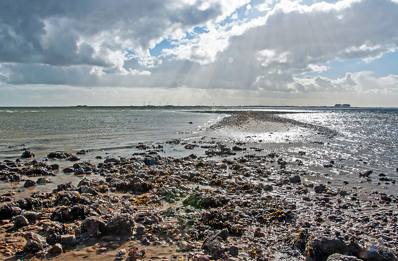
Much of the estuary floor is characterised by shallow subtidal mud communities dominated by marine worms and Baltic tellins while subtidal muddy sand is dominated by bivalve molluscs (Natural England, 2000). While soft substrates such as mud and sand dominate Essex Estuaries SAC, there are also areas of hard substrate (Natural England, 2000). Areas on intertidal boulder and cobbles support diverse communities, as sedentary species including seaweeds, hydroids and sponges can gain a foothold. The long history of oyster cultivation in Essex Estuaries has resulted in the presence of oyster ‘culch’ (cockle or clipper limit shells) covering large areas of the seabed (Natural England, 2000).
Sandbanks which are slightly covered by sea water all the time
Subtidal sandbanks in Essex Estuaries are typically composed of gravelly and clean sands and are found in high energy environments.
Conservation objectives
Ensure that the integrity of the site is maintained or restored as appropriate, and ensure that the site contributes to achieving the Favourable Conservation Status of its Qualifying Features, by maintaining or restoring;
Ø The extent and distribution of qualifying natural habitats
Ø The structure and function (including typical species) of qualifying natural habitats, and
Ø The supporting processes on which qualifying natural habitats rely
Site uses
The site is large and a variety of fishing methods are undertaken across the site. Commercial fishing, including potting, netting and trawling, occurs within the site. There is low level commercial clam dredging in the river Crouch. The site also boasts an extensive cockle fishery which has been managed under the Thames Estuary Cockle Fishery Order (TEFCO) since 1994. Bivalve mollusc mariculture occurs on the site, specifically for oysters (both native and Pacific) and mussels. Harvesting of bait and shellfish occurs on the shores.
KEIFCA's role
KEIFCA is responsible for assessing the effects of commercial fishing within this site and must implement appropriate conservation measures to avoid damage to EMS by fisheries activities. In Essex Estuaries SAC an area where intertidal seagrass occurs has been identified as at risk of damage from bottom towed fishing gear, and in response KEIFCA have implemented a Byelaw prohibiting the use of this gear over the seagrass feature.
In addition to assessing the site and creating management plans, KEIFCA is also responsible for the enforcement of fisheries bylaws and regulations within this site.
© Kent & Essex IFCA 2026 - All Rights Reserved | Privacy Policy
| Website by ![]()